 |
We take a short drive up the Oak Creek Canyon towards Flagstaff and find a little forestry campsite which happens to be quite full. Lots of kids on school break and it is the start of the Easter weekend. We can feel the chill as the elevation rises. Probably at 6000'. Nice to have a big fire that night.
 |
Drive up to the Grand Canyon and grab the last campsite at Mather. It is the most convenient as we will be heading off early next morning. Surprised how busy it is. I guess with spring break and Easter, the crowds are much larger than when we were here last May. The hike this morning is Grandview to South Kaibab. Over the last 2 years, we have hiked much of the Tonto trail and this is the one section we missed last year. At 29 miles it will be the longest and a 5AM start is the plan. This will be the first time in the canyon that my partner in crime will not start with me as she is having some back problems so she will meet me at the other end. She ends up hiking around 20 miles so I'm sure she could have walked the distance with me.
Started off at Grandview in the dark. Glad I had my headlight as it is a steep trail down to the Tonto, with many shear dropoffs and the trail is not as hiker friendly as the busy corridor trails.(Bright Angel/SouthKaibab) .There was still ice on the trail for the first 1000' vertical. This is a shot of the sun rising on the red canyon walls after an hour hike down. |
|

Looking down on Cottonwood creek and the Tonto trail. The Colorado river is in the gorge at the far right Weather was below freezing when I started but after dropping 2000', I started peeling off layers. This is a part of the canyon where no aircraft over flights are allowed and it is so quiet. I will see no one for 4 hours.
 |
| This is the junction of the Tonto trail coming from New Hance trail. Lots of water flowing in Cottonwood creek as well as a lot of trees and bushes making this a popular camping spot. |
|
|
 |
| This is a typical side canyon that you have to hike around. This one (Grapevine creek)is the longest taking over 2.5 hours to skirt and only gaining 1/4 mile in a straight line which is the point right across from where this shot was taken. |
 |
| The Grand Canyon is like no other in the world. Get out and instead of just seeing it from the rim, get down and dirty and experience it from the bottom. |
 |
| This is typical of the trail which follows the canyon walls at the very edge giving you a superb view of the chasm where the Colorado river runs through. |
 |
| Looking at the ridge that comes down from the south Kaibab trail. It was 2AM when I took this photo and I thought I am almost there. What I didn't figure into the equation was the 2 canyons that I couldn't see between me and the switchbacks that lead up to the rim. I'm heading for the flat area that is to the right of the ridge. It is very busy for the canyon because of the school break and Easter and by the time I get to the bottom of the South Kaibab trail, I will have met 30 backpackers. No dayhikers as it is a long way from the access trails and most people are not dumb enough to do this trip in a day. |
 |
| Mrs. Crosscheck has found me wandering in the wilds of the canyon and takes a picture of the crazy set of antlers that I found on the trail and the crazy coot who has them.. |
 |
| Mrs. Crosscheck setting the pace up the South Kaibab trail. It was around 5:00 and we were almost the only ones on the generally busy trail. It took us maybe 2 hours from the Tonto to the rim. Nice weather although it did get cold towards the top. |
 |
| As we climb up the trail we can look down at the Tonto trail and the North Rim which is on the horizon. |
 |
| Last look at the canyon from Cedar lookout before we make it to the rim.Crosscheck is a little tired after a 13 hour hike but the weather has been pleasant not hot. |
 |
| Pull in late to our favorite boondocking spot in the Kaibab Forest. Too tired to light a fire, Very peaceful. No one around. Morning brings some sun although it is below freezing. Heading to Zion and the St. George area. |
 |
| Start driving to Utah around the St. George area for some mountain biking. Stop in Page for lunch. It seems every time we are here, Lake Powell is lower. Where is all of that water going? |
 |
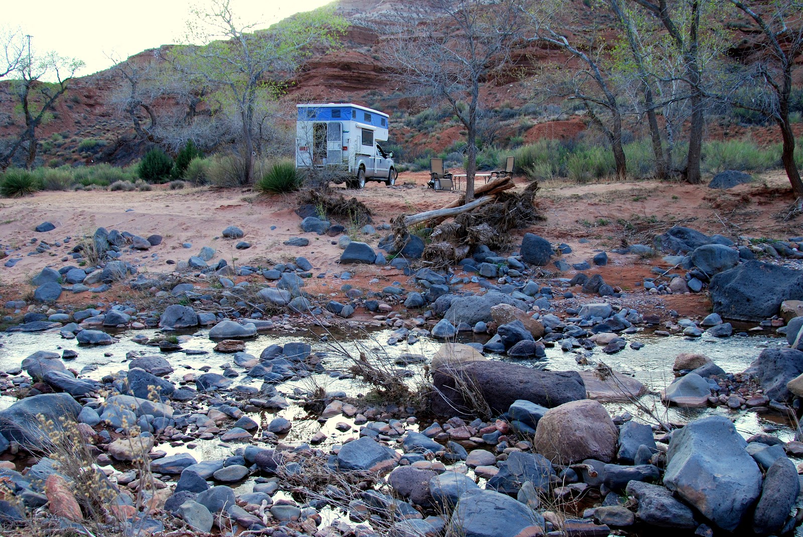
| We travel through Zion hoping to hike up to Angels Landing and beyond but there are so many people gathered around the information centre that we know that the trails are going to be busy. Decide to head out of town and camp in a quiet area out of Virgin by the creek. Lots of firewood , she with her wine, me with my G+T's. Why would anyone want to stay in a campground? |
 |
| It's nice to be beside a creek for camping. In BC every where is moving water so you are never very far from the sound of a creek or river or lake. |
 |
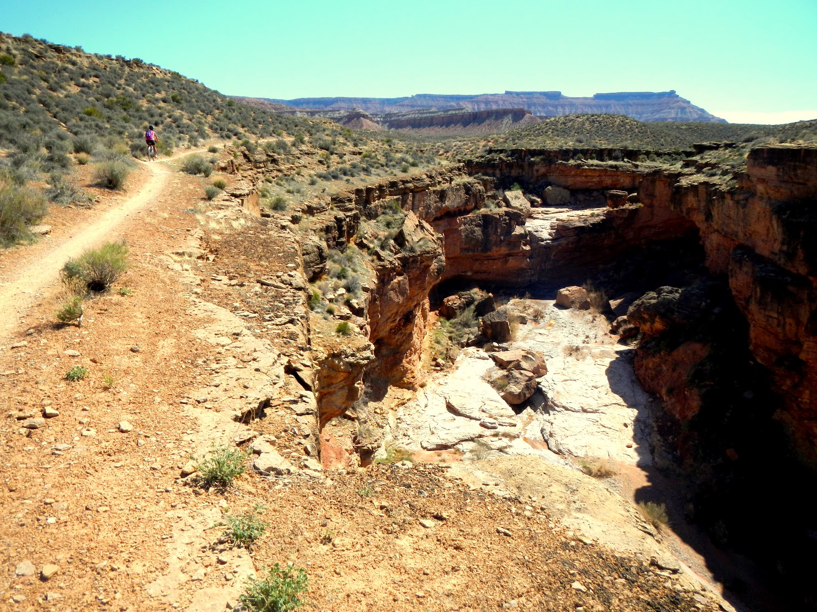
| Travel down into Hurricane and drop into the local bike shop for info on the area. Great bunch of guys. We park up on the plateau and head out on JEM trail which starts off following a small canyon. |
 |
| Starting up on J.E.M. trail. Passing by a small canyon. It will seem like a baby compared to what we will be riding next to in the coming days. |
Blogsy How-To
 |
| On our way down Goulds rim trail. Follows a set of canyons all the way into Hurricane. |
 |
| After grinding up the hill above La Vergan on the Hurricane Ridge trail we come to panorama Point viewpoint. Great 360 degree views of mountains and canyons. From here we cycle along the canyon rim and then back to the truck. |
 |
| Looking towards Virgin where our truck is parked. Down below is a trail where there used to be an irrigation canal. By the time we finish the ride, we will have been away for 6 hours. Definitely one of the toughest mountain bike trips we have been on but the canyons were outstanding. |
Pretty wild canyon riding. We are close to the point of The messa.
 |
| Drive up to Gooseberry Mesa passed the windmill trail head and get a little chair time. We are looking down at the area we rode yesterday. Spectacular country and so colour full. Can't wait to ride the slickrock later on. |
 |
| Big campfire, good food and drink. Tired muscles. Howling coyotes. Ain't camping grand. |
|
The north ri m trail follows pretty close to the canyon where if you had a fall or lost control for a second it would be a long and pain full fall to the bottom. m trail follows pretty close to the canyon where if you had a fall or lost control for a second it would be a long and pain full fall to the bottom. |
 Looking back from where we have riden along the canyon edge. Looking back from where we have riden along the canyon edge. |
 Getting pretty close to the end of Gooseberry Mesa. Getting pretty close to the end of Gooseberry Mesa. |
 |
| Riding the practice loop on the slickrock trail with Zion NP as the scenery. |
 |
| Last trip down the slickrock trail before we head out to the Church Rocks area north of St. George. We ride the prospector trail, climb up Church Rocks and then back to the truck. Very nice slick rock, and single track, mostly intermediate and then head out of town looking for a camp spot. |
 |
| Drive up a road from Leeds and find a nice dispersed campsite with a great view of Gooseberry Mesa across the valley where we were biking for the last few days. Sun just setting. Great memories. |
 |
| Last night before we take the long haul back to BC. Lots of good memories and not too much blood was spilt. |
 |
| Drive north and crash at a truck stop west of Boise. Travel until we are tired and end up in Slocan City , BC in an old sawmill site on Slocan Lake. |
 |
| Pass by Summit lake on the way to Nakusp. Yes that is ice on the lake. What a difference a few days can make. |
 |
| Looks like we are back in BC. We are on the ferry with a mixed bag of truck loggers, locals, tourists, bikers, construction equipment and us. Looks like we've pick up a few bugs on the way. |
 |
| Along the banks of the Columbia river south of Revelstoke ready to camp. We will stay the night and then head home to Coldstream, BC. |


 m trail follows pretty close to the canyon where if you had a fall or lost control for a second it would be a long and pain full fall to the bottom.
 Looking back from where we have riden along the canyon edge.
 Getting pretty close to the end of Gooseberry Mesa.


No comments:
Post a Comment