The mule is packed and ready to go. It is late March and time to head south where the sun shines a lot more than here. Usually we head out around the last week in April but Pat has itchy feet and wants to get away from the cooler temps and into perennial sunshine.

At a truck stop somewhere in Montana where we stop for lunch and soak up the sun.

Heading south on I-15. Still a fair bit of snow on the local mountains in early April.

Stop off for a lunch break on the road leading to Yuba Lake State park. Notice the clear sky,s and the pasty skinned tourist.

Turn left off I-5 onto #17 to La Verkin before motoring through Hurricane and then up 8km on #59 before turning left on Sheep Bridge road. Down about 1.5km and camp at a range water tank. Not far from the JEM mountain bike trail. This will be our home for awhile. Nobody around, still a little chilly in the evening but we have firewood and the sun is shining.

Pat on our first day of riding since Sept/15. Heading up to the top of the JEM trail.

Pat ripping down Dead Ringer on the way back to our truck. Thought we would just take it easy this first day so that there would not be any blood spilt.

She is now just a little speck in the horizon soon to go around the corner.

A look down lower JEM towards our TC which is just a speck in the small stretch of red dirt in the middle of the picture. There is an American holiday this weekend so a lot more RV's than normal are parked in the area.

She never misses a time to train, stretch or work on her core. In the background is a watering hole for cattle with the area full of flies and cattle poop.

Move our spot a little farther up the hill so we have a better view.

Super Dave on his way around the Hurricane Rim bike route. We rode this section a number of years before, only this time we are riding it in reverse. Overlooking one of the smaller draws that leads us to the main canyon. Going counter clockwise.

The bike trail follows the rim of the Virgin River canyon which is fed by runoff from the Upper Zion park.

Pat stopping for lunch at a look out for the canal trail which can be seen part way up the canyon walls. It is now a walking trail but at one time there was a canal built along this route to bring water to the farms below in La Verkin and other areas as this country seems to be dry all the time.

We ride down a steep hill to the trailhead by some communications towers, ride down the highway a half km and then cross the highway to the left and ride up a long, steep road called Gould Rim. From here we we continue along until the road turns into a trail and follow it up until we cross the main hwy#59 and are now at the top of the upper Jem trail. From here it is a quick descent down to our truck completing the long canyon loop.

Decided to take a break from mountain biking and go for a hike up into Zion NP. We knew it was going to be busy but the lines for the buses were crazy. I guess with all of the schools out, a lot of families were heading to the the local State and National Parks.

Todays hike will take us up past the Weeping Rock, through Echo Canyon coming eventually to the fork in the trail, the left going to Observation point, the right to Cable Mtn. and onto the Deer Trap Mtn.

Pat standing at the trail to Cable Mtn. which we hiked to a few years before. We are heading straight today for our destination Deer Trap Mtn. which is new to us. 25km return.

Looking south into the canyons feeding into the main Virgin River canyon.

Some sort of a local horny toad.

Our first look at the Zion Lodge, almost a speck on the valley floor, where much of the lumber used to build the structure came from the larger trees growing at the higher elevations where we have just hiked. We had not seen anyone once we left the trail to Observation Point so it was kind of special to be alone in this famous National Park on a national holiday while down below in the valley, it was so crowded with people.

When we left this morning, the parking lot was almost empty. We hiked more than 25km and were above most of the high ground you see in the back ground. A long dusty day but not unusual for us.

Decided to stay around the area and hike to Kolab Arch which has been on the list of to do things. Instead of going back to the camping spot above Hurricane, we travel up a forestry road which follows Leeds Creek where we knew there was some primitive camping. The drive up to The Kolab Arch turnoff was not too far up along the I15 and then we drive up to the trailhead.
We stop for lunch along the La Verkin Creek near where the short 5 km trail to the Kolab Arch heads up river.
Pretty impressive arch although because of the sheer cliff walls all around it, you can't get very close to it.
We get back into the main La Verkin river valley and head up river past where you meet the Hop Valley trail. We hiked in from the Kolab reservoir road a few years before to this spot. Get to the last campsite just to when the canyon starts to narrow and then head back down to the trailhead.

Our plan is to go back down to St. George and stay in the Snow Canyon area and do some hiking/mountain biking. We get a spot in the SP but only can get a small, narrow, full serviced lot where you can almost touch your neighbour and no fires so for one night, we hold our nose and go hiking and biking around the local area.
The weather was colder than we anticipated so a decision was made to head to Sedonna and bike there. As we got closer, the wind and rain made it easy for us to head further south to the Mesa area and Lost Dutchman SP. Definitely a cold spell was going through. This is the low desert in April and Pat has her hands in her pockets and a rain/wind jacket. It should be in the low 30's as a high.
Get a nice spot with a good view in the no services area and drive to the Peralta trailhead for a afternoon hike around the Weavers Needle. Even though we have hiked this trail before, we were starting the trip in the afternoon and it was to take us 6 hours for the round trip.
Because of the rains, the cactus were in bloom.
From this point we hike down into the bottom of the gulch and then the long hike up the other side of the "Needle"as we will traverse the 3rd side of the rectangle. It is getting late when we get back to the parking area which was crammed with vehicles when we left and now there is only 2 others plus us. Wanted to hike up to the Flat Iron and beyond as we had not stopped to view Mesa and the surrounding areas from the Flat Iron when we did a through hike a few years before(Lost Dutchman to Perralta road) and rode our bikes back to the SP. (10 hours) This is the first time when the trail gets steep. We are heading to that jagged group of rock top left centre and beyond.
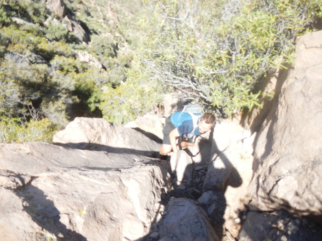
A couple who we met on the only steep section where you needed handholds to climb up this part of the cliff. They were not sure which way to go so we helped them pick a route up.
Interesting rock formation as we hike past the Flat Iron and over the top.
On the lower part of the Flat Iron looking south along the ridge we hiked a few years before. Past the farthest peak in the background, the trail drops sharply down to the Perralta road.
Back at the State Park to one of the most famous rock formations in the area, Superstition Mountain seen at sunset.
Had not done any mountain bike riding in the area so we though we would give the trails along the south west side of the mountain a go. This is the Lost Dutchman Trail.
This is Pat stopping among the Saguaros. Temperatures have risen in the last few days and we can feel the heat for sure.
Started a hike at the Perralta trailhead and we are doing a round trip taking all day.
Backpackers from the north-west on a three day round trip of some of the trails. Almost no water so much of the weight you carry is fresh water when out for over a day.
Towards the end of our hiking trip, we are treated to an interesting rock formation.
Finally say goodbye to the Superstition mountain area with its warm, sunny weather and head out past the Roosevelt Lake a route we have never driven. Take #60 to Globe, then hang left on #188 until we hit the junction of #87, climb up to Payson, over the top and then back down into Cottonwood.
We camp that night at Dead Horse State Park, do a little mountain bike riding and then next day drive out on #89A , turn left on a forestry road and stake out some ground out at a dispersed camping area 5 km from Sedona.
Weather is still kinda cool but the sun shines so all is well. We start the day off riding from the Adobe Jack trailhead which are trails that are new to us. Mostly intermediate terrain but still a challenge for us. Do a bit of a loop and then head back to the camping area.
Next day it is on some familiar ground, Cock comb, Rupp, Dawa, Aerie, Ginger, Snake and a bunch more trails.
Back camping we get a surprise in the morning with 5-6 big hot air balloons heading near our boondocking spot on their way to Cottonwood.
Next day it's all of Chuckwagon(where Pat gets a flat even though we have slime in all of our tubes) then onto Gunslinger, Long Canyon,
Pat is ripping up the red rock on the Mescal Mtn. trail.
It takes a full day to do the whole loop. We ride below the cliffs in the background.
Meet this tattooed guy from Tucson on a fat bike which is fairly rare on these trails. Says he likes his bike because of the trips he takes in the back country where there is a lot of sandy areas.
Pat finishing the last climb before heading down to the truck on the Long Canyon road.
Nice food and beverage parking spot at the end of our ride and every day is sunny.We find the hiking in
Sedona is marginal at best but one of the nicer routes is Bear Mtn. which is really just the top of the eroded plateau maybe a 2000' climb. Not much more than a 1 hour hike to the top where you can view the snowy peak of San Fransisco Mtn. in Flagstaff 50km away
Drive to the South Rim, Grand Canyon for some hiking. Stop for lunch and pick up wood just outside of the NP boundary. Because of the possibility of lots of rain in the future, we decide to miss the Grand Canyon and head down to the Buckskin canyon and hike this area before the rain storms hit.

Stop the night at Lone Rock State Park just west of Page. No wind this time. So peaceful. Have a nice meal and fire by the lake.
 As the sun goes down and the moon comes out, Pat rests by the fire with some red wine, good food and of course great company in the presence of Super Dave, her companion of 37 years.
A few years before we caught a ride from White House campsite to the Wire Pass TH. From there hiked the 20.9 miles to our camp. Spectacular. We thought it would be nice to try it again. Total hiking time a little over 8 hours.
It was about 1.5 hour hike down to the confluence with Wire Pass and then we hiked down Buckskin Pass until late afternoon. Lots of day hikers.

Pat scrambling up one of the places where rock falls required hikers to climb up the large boulders using hand holds. It is one of the more unique hikes we have ever done but the hike itself is relatively flat and not difficult, just long.
Nobody around as Pat makes her way down the slot canyon. We see logs and debris stuck high up the walls which just goes to show how much water gets queezed between these walls when there is a flash flood.
Packed our bags and headed to Red Canyon State Park not far from Bryce Canyon NP. We checked out the mountain bike trail over Thunder mtn. but there was a lot of rain and cold weather in the forecast so we headed into Bryce and found a camp spot. Pretty cold temps with snow falling in the night. Woke up to the white stuff. We had planned to drive to Boulder on #12 and then down the Burr Trail and do some hiking in that area. Found out a cold system was about to hit us and we decided to head out to where the best weather was and that was Moab.
At Boulder, the temperatures were cool at noon but as we ascended to Steep Creek lookout near the summit(9200') it was 30F and snowing like crazy. It was a white knuckle drive down into Torrey and we are experienced with winter driving. Got into Moab and camped at the North end of Klondike Bluffs Mnt. bike trails. Here is Pat hiking up the Dinosaur trail in a rain shower.
Weather finally cleared up and we saw the sun but it was still pretty cool out. This weather was going stay cool for the next week in Moab. We find a nice spot on Dubinky Well Rd. only a km from where the Navajo Rocks trail crosses the road.
Ride 15 minutes from camp and get on the Navajo rocks trail near Big Mesa.
We are riding the full loop today which is a combination of 4 shorter loop trails.
Pat checkin out the scenery. Lots of fun slick rock and mostly, for us, all ridable.
Heard about Amasa Back so decided to hike the trails as there were thunderstorms happening around as, which made the trails a little bit more tricky with the water and mud. Found out they are tough trails.
Got a campsite at the Horse Thief campground and set up for a few days riddin in a new mountain bike area.
Looks like today is all about intermediate riding and we find ourselves heading up of course 7-up.
Next day is a trip down bull canyon. This is where Dave crashed a few years back and was impaled by a dead Juniper branch. Long bloody walk out of that place.
Really scenic biking along the canyon.
Lunch break coming up Getaway. It's a long chug up from the bottom of Bull Canyon to the campsite at Horsethief.
Pats bundled up for an evening around the fire. Pretty chilly with the wind. We are up around 5800' and it has been cooler than some of the years we have been here. \\
you can see the fresh snow of the La Sal mountains in the background. We met some riders from Denver who had been coming here for more than 20 years. Said this is the first time they have ever seen 4 rainy days in a row. They gave us their 10 bundles of firewood because they decided to leave for home early because of the cool wet weather forecast.
Headed down to Natural Bridges NP and pulled into the campground. Planned to use this area as a base to hike some of the canyons in the area. This is at the top of the rim on the cross country hike to Sipapu Bridge.
Pat descending down to the bottom of the White river canyon.
Don't know which bridge this but we are doing a round trip hike from our campsite to Sipapu, down the White river to Kachina and then left onto Owachomo bridge. From there we bear left and ascend up the Tuwa canyon back to our campsite.
A ruin near Kachina bridge.
Owachomo bridge.
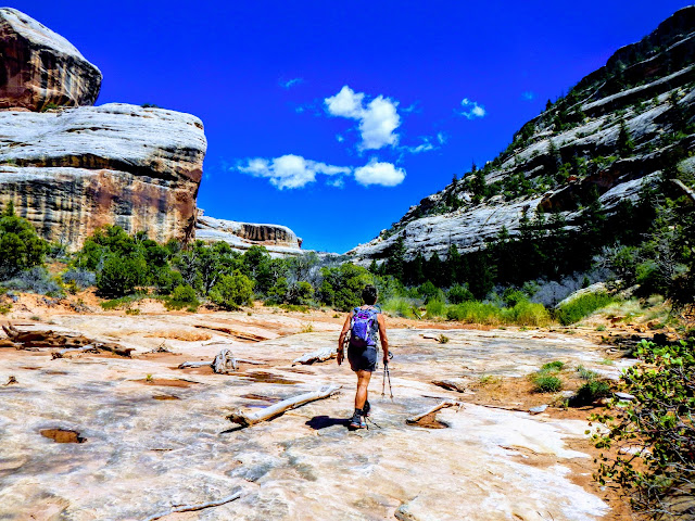
This is the beginning of the Tuwa canyon. It has been wet this spring and there is water flowing in these usually dry canyons.
Dave takes the cliff path while Pat removes her boots and wades through the bottom pond to get up over a ledge.
Just after a rain fall.

On our way up the White river after turning right at the Sipapu bridge. This is one of many native ruins.
Canyon walls are decreasing as we ascend to the top of the canyon.Head down to the south fork of Mule canyon. Tried to hike this canyon a few years before but were caught in a real thunder storm and decided to come back at a different time. This is just one of the many Indian ruins found along a 5 km section of the canyon. We found the trail was quite busy with tourists.
Our plan for the day was to hike up a ways and find a side canyon where we could access the plateau and from there drop down into the North fork of Mule canyon. No such luck. Made it fairly close to the end of the canyon after a lot of scrambling but a steep headwall kept us from going further.
This is the trailhead for Collins Spring. Having walked most of the Grand Gulch and tributary canyons, though it would be great to head down from Collins Springs and head up Grand Gulch to Banister House.
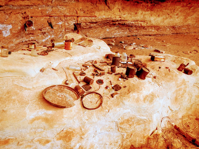
Soon after you start down the canyon is an old cowboy camp full of relics and trash from bygone years, mostly glass, rusted metal cans, some leather and wood. No plastics or rubber.
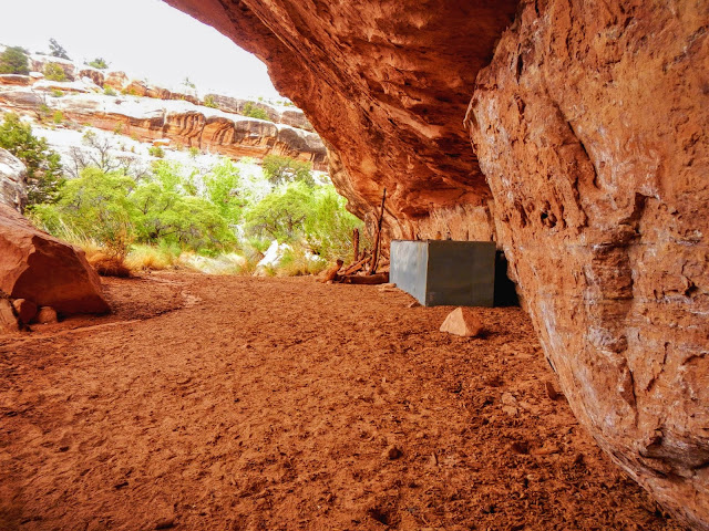
This camp is situated ,like many of the Anasazi ruins, under a big undercut giving protection from the rain and sun.
Didn't see any hikers/backpackers on this jaunt. Had the canyon to ourselves.
Time to head for home. We had never driven this way, #276, before which is to cross lake Powell on the Bullfrog ferry.
Headed straight north until we Though we would stop at Missoula for some mountain biking. This is one of the trails at the Blue Mountain recreation area where there were hikers, bikers, dirt bikers, dog walkers. Spent 2 days in the area peddling up and down this fun place. I70 then it was through Price and onto SLC.
Somewhere in Montana
Stopped in Spokane for a little shopping before heading north and home. Stayed the night a a wet camping area alone the Spokane river.
This is a foot bridge over the river. lots of water this year and the river was pretty impressive.
Looking down the Spokane River at the rock formation called the kettle and tea cups?
Headed straight back across the border next day without any issues a little earlier than we had planned. More cool wet weather than previous 5 trips but there is always something interesting to see. More mountain biking this year less hiking because of the lack of access on many of the wet, slippery back roads after rains.


No comments:
Post a Comment