 Snow is melting fast in the end of February but there is still 2 months of winter left up the mountain. Time to get out of town and travel to the low deserts of the SW USA. Visions of Saguaro and Cholla cactus, bright, warm sun and endless margaritas. Just packing up for a 5 week trip. Hey honey, have you seen my speedo?
 |
| Get a late start out of town and only make it as far as Bridgeport close to Chief Joseph Dam on the Columbia. We find a campground but it is closed so we just pull up and make ourselves at home. We are all by ourselves. |

Stop for lunch near a summit for the Old Oregon Trail. I thought we left all of that white stuff behind? Yuke. The old pioneers had to deal with a little more than slippery snow and poor TV reception
 |
The roads coming down from Oregon into Nevada were so quiet, even the coyotes were lonely. I forget the name of this town but we came up this pass just south of the town.There was a big cemetery and a mine to .  Stayed overnight at the casino in Winnemucha and was woken up at 4:00 am by haul trucks headed to the mine. Not a bad sleep up until then. Lots of gambling happening. Get into Scotties castle at 4:00 and head off down to the Mesquite Spings CG.  Our first taste of desert sun. Still a bit cool here with a bit of a wind but the warmth feels good on this pastie skin. The added 140W solar panel is working well giving us 330W in total supplying us with lots of surplus 12V power.  Ubehebe Crater. Got to hike around the little one and the big one. As I took a shortcut from the top and ran down the sand to the bottom, Mrs. Crosscheck walked around the perimeter.  There's Mrs. Crosscheck that little speck on the crater rim. She,s in the penthouse, I'm in the basement.  Here we are again in Stovepipe. Hardly anyone here. It's a little windy today and the temps are a bit cooler. We hope to hike up Mosaic Canyon past the dryfall and then keep going up and see how far we get. The mountains behind are 6700+ft high which is a lot of vertical.  Mrs. Crosscheck humping up one of the small dryfalls in Mosaic Canyon. We will eventually hike more than 3 hours further until the going get pretty steep. She said her running shoes had no footing on the small rocks in the steep areas. Lots of Sheep trails at 5000'.  Still heading up following game trails. Stovepipe is just a speck on the desert floor. Grass is starting to grow at this elevation and there are a few small creeks running.  That night at Stovepipe a strong wind came up and flattened a tent set up by a young couple from LA. They said this was their first camping trip and that their cheap Costco tent was toast. They had a nice sleep in their Ford Focus in the middle of the night. Those budget dome tents are fine as long as there is no wind or rain, or cold, or bugs or..... As we had been in Death Valley last year in Feb. we wanted to head south to Anza- Barrego Springs SP and check it out. This is a dispersed camping area in from the Salton Sea. Very flat. As you can see a fair few RV'ers.  This is our first sighting of the Carrizo Gorge railway and an old water tank.We drove in on the Montaro Wash road. We had lots of time to poke around at all of the old treasures from decaying buildings and walking the trestles. We planned to stay the night here and hike to the Goat Canyon trestle tomorrow.Thanks to Whazoo for getting me interested in this area of the State Park. Lots of new windmills down the valley towards Occatillo Wells giving us a foreshadow of what would happen next night.  Another night under the stars listening to the gentle sounds of cholla moving with their warm and fuzzy branches in the breeze.  Off on a hike to the trestle. One thing you find out real quick when walking in the desert is that everything is armed and dangerous. The worst is the cholla that falls off the bush in a wind and it will go right through the light foot wear we have.  In the middle of this rock canyon with hardly anything growing, we bump up against these palm trees which means there is surface water.  Our first sight of the railway coming through such a desolate area. Looks like a turkey buzzard would have a tough time making a living here.  Here is the largest wood trestle in the world. Just as I was taking this shot I notice some movement on the tracks and sure enough after getting my binos out, there were 2 mountain bikers crossing. I said to Mrs. Crosscheck, we have to do that as it would be neat to cycle through all of those tunnels. We hike back to the TC as the wind picked up. I had parked the Camper sideways to protect us a bit when we had the fire that night but the wind was so strong that we eventually went to bed. My wife at 2 AM said she thought the Outfitter was going to blow over and she wanted the top down. So, I dropped the top in a howling gale and drove the truck into the wind so there was less surface area and went to sleep in the lower bunk.The old Outfitter was rockin and rolllin for sure that night in the wind.  We went up the road to a spot called Mountain Palms CG. No services, no cost. Works for me. From here I was hoping to get some info on where to access the railway but as no one around there knew anything about this and we did not have internet, we just had a walk around all of the area including more palms.  Sure enough. Everything was bone dry as we walked up the canyon. As soon as we sighted these palms, the ground was wet and then there was a trickle. Water is life in this desert.  This is pretty typical of the desert around here. Lots of boulders. Ya can't get lost because there ain't no trees.  Rain or drizzle was predicted for the next few days so we packed up and started driving south then east. Passed through Yuma which was just crawling with RV's. Kept driving on the way to Tucson .Wanted to climb Pacacho Peak so we pulled in and got a campsite which was electric, no other options. Woke up next morning and found the clouds down to the road so we said," I'll be back" Headed out to Tucson next morning and found a spot in overflow at Catalina SP. As you can see, there is a fair amount of clouds around. Rain or drizzle was predicted for the next few days so we packed up and started driving south then east. Passed through Yuma which was just crawling with RV's. Kept driving on the way to Tucson .Wanted to climb Pacacho Peak so we pulled in and got a campsite which was electric, no other options. Woke up next morning and found the clouds down to the road so we said," I'll be back" Headed out to Tucson next morning and found a spot in overflow at Catalina SP. As you can see, there is a fair amount of clouds around.  Started to drizzle that after noon as we headed out to the Romero pools. Believe it or not it was kinda cool in the wind as you got up the mountain.  There was a lot of gossip by the other Saguaros around this guy and said he's just a flashy show off with too much nutrients. I guess the word on the desert is that some motorhome sat for a long time and was discharging not only his grey water but also his black right into this guys roots.Well according to the scuttlebutt, everything went right to his head. Early ripe early rot they say.  A lot of people were bird watchers in the Catalina State Park. This is one of the more colourful birds around. It's a Vermillian Flycatcher I think.  One of our hikes as the weather got warmer was up the Sutherland trail via a few dead ends. It ends up near the top of Mt. Lemon. If you look closely at the top ridge, you should see the fresh snow that fell over the last few days.  Mrs. Crosscheck balancing beer, sauce and chips after a long hike. Crosscheck is well ahead of her in the beer down department. And every day is sunny. Still cool but temps are on the rise. Mrs. Crosscheck balancing beer, sauce and chips after a long hike. Crosscheck is well ahead of her in the beer down department. And every day is sunny. Still cool but temps are on the rise.  One of the mountain bike trails that you could ride right out your back door was called the 50 year trail. You would see of course mountain bikers but also lots of horses and hiker/runners. Motorised vehicles were verboten. The scariest thing about riding here was the fact that the prickly pear cactus and the cholla were inches away from your tires and many times on the path. Glad we switch our tubes over to slime filled.  Mt Lemon(9100'+) in the background with new snow on the ridge.Great horse riding area  Today we plan to hike up to Romero Pass and splash in the pools on the way through. Hiked up with a couple young guys who were not carrying any water. The temps were getting close to the 90's as a high. That water sure looked inviting to swim in.  We arrive at Romero pass, 6000'+ and there is an option of going up the ridge or back down a few different ways.  Crosscheck cooling off as the temps rise as we get to the Romero pools after coming down from Romero Pass. Just thinking about that cold beer waiting at the TC.  We drive north for about 20 miles and end up at the 24 hour mountain bike race course which is a figure 8 single track through more cactus than I have ever seen. I guess if they crach into the cactus, the competitors keep a fine tooth comb to brush out the cholla spines and for the larger prickly pair, pull them out and apply duct tape to staunch the flow of blood.Mrs Crosscheck looking at all the pretty cactus knowing that they all want a chunk of her flesh.  There are 2 Saguaro NP's in Tucson, an East and West. We start up the east one heading along the ridge to Juniper camp. Meet backpackers from many different places who are sitting in the shade wherever there is any. Pretty hot today but we are used to the heat by now and we carry enough water to get by on. Soon leave the Saguaros behind. Looking down on Tucson.  We find some skuzzy water to cool off with. We meet a number of hikers from many areas including 3 young local guys who have spent 3 days backpacking. As we catch up to them on our way down they break into a trot. Eventual 2 of the guys stop for a break but the other keeps motoring all the way to the bottom. Later we talked to him and asked him why he didn't wait for the other guys and he said that no old guy (meaning you know who)with long shorts was going to beat him down. I gave them all a beer and invited them up to BC for some cool backpacking. They seemed surprised that we went up to the same place they camped at and down, in the same day. I told them we do this a lot and we were not carrying anything like they were.  Get back to the Outfitter and the NovaKool fridge has the beer ice cold even though the TC has been in the direct sun for 6 hours and we notice the batteries are still up.According to the weather channel, it hit 93F in Tucson that day. It was a good suntanning day.  Drove up Mt Lemon to check out the most southerly ski hill in the USA. Lots of "roadies" biking up the mountain. Looks like an area where desert dwellers could escape the oppressive heat in the summer.  Another evening of picking cactus spines out of the tires while the sun sets on Mt Lemmon and the G+T's flow like water.This is our last day at Catalina. From here we hit Pacacho Peak and then on to the lost Dutchman SP.  Drive out to Pacacho SP where it was a holiday weekend, school break and some sort of reenactment of a civil war battle that included lots of musket fire and cannons. Mrs. Crosscheck on a mission to conquer Pacacho Peak which we bypassed a week earlier.  Don't step back sweety or you might go over the wire and it might mess up your hair when you bounce off the rocks.  There are quite a few cables to help hikers up to the peak because if there wasn't any there might be a lot of carcasses for the buzzards to feed on. Lots of big dropoffs.  This is that Turkey Buzzard that is looking for mashed hikers on the rocks below.  We arrive early in the evening at Lost Dutchman SP and are put in the overflow camping ,no services, which we think are better than the serviced spots except that the showers are a fair ways to go but we have bikes so no problem. Another classic desert scene with the saguaro standing guard as the sun sets on Superstition mountain.  We sit and relax watching the changing colors on the walls of Superstition Mountain as the sun disappears.  We asked at the info place where there was good mt. biking and they sent us off to Jacobs Crosscut trail which turned out to be big boulders once we left the park heading toward the lost goldmine trail. Spent most of the ride pushing the bike. Note to self. Never ask a non biker where is a good place to mt. bike. Later on we meet a knowlwdgeble person who gave us lots of info on good areas to ride, mostly a fair drive from the park.  Today we hike up to the flat iron and then leave the hoards behind by taking the scenic route over the ridge and ending up on Peralta road where our mt. bikes are. This is where the trail starts to get steep and many stop here. If you look to the top centre left of the picture, you can make out the Flat Iron cliff wall. It is steep.  The last section up to the flat iron is not hard but is steep and has a few short sections where handholds are necessary. Mrs. Crosscheck is giving me a dirty look and saying she'd rather be shopping.  This is the Flat Iron. A pretty impressive piece of rock especially when you dangle your toes over the edge and look down on the CG. We leave all of the hikers behind and we will not see anyone for 7 hours as we hike the ridge.  We are heading for that peak in the far horizon. From that far peak we will hike 1.5 hours through some canyons and then it is 45 minutes down to the bikes where we will cycle 2 hours back to the park. Mrs. Crosscheck figures we'll be cycling in the dark. I think we will be alright. Trust me I said. We are still alive after all of these years aren't we?  We meet up with this friendly guy on our hike along Superstition ridge. I would have like to get a little closer but I think I would look real funny with a big puffed up face if he decided to strike.  We pass by Weavers Needle as we travel along the ridge. Mostly there are cairns which we follow but we do lose the trail every so often. In a few days our hike will be in the valley below us as we circumnavigate the Needle.   Looking down from the pass at the road where out bikes are parked which is at the end of that green section.Very green for a desert we are told.  Ahhh our trusty steeds. It is 21 miles back to the Outfitter on gravel and paved roads. I say 2 hours which will put us in after dark. The 8 hour hike was long but our legs are getting stronger after each hike that we try.  This was a friendly guy that wanted to be picked up. We were not brought up around snakes so even a harmless bull snake gives my wife the heebee-geebees. Whazoo can pick them up but I just booted this guys butt off the road as I had seen a few flat ones while on this trip.  Crosscheck seeing how warm the water is at Canyon Lake which is on the Apache Trail on the way to Roosevelt Lake. He was accused of trying to impress some young sweeties that were on the beach sun bathing. It didn't work. Crosscheck seeing how warm the water is at Canyon Lake which is on the Apache Trail on the way to Roosevelt Lake. He was accused of trying to impress some young sweeties that were on the beach sun bathing. It didn't work.  On the recommendation from a biker from the park, we drove through Mesa and headed north on north power road near a rec area that had a small lake and had a 3 hour ride through some very nice single track . I forget the name of the area but there were some good climbs and views.  Every day since we had the drizzle in Tucson a few weeks back has been warm and sunny. Pat riding down heading for the truck.  Head out to the Peralta trailhead which is packed with vehicles. There are a lot of trails that take off from this point and most just go as far as the pass where this shot is taken. We drop down the other side and bump into a few hikers coming back up and 1 lady from Colorado who has her dog with her. She said she started at 7:30 in the am to keep away from all of the tourists. Walked down to the Dutchmans trail and caught the Teripin trail back to the parking area. Head out to the Peralta trailhead which is packed with vehicles. There are a lot of trails that take off from this point and most just go as far as the pass where this shot is taken. We drop down the other side and bump into a few hikers coming back up and 1 lady from Colorado who has her dog with her. She said she started at 7:30 in the am to keep away from all of the tourists. Walked down to the Dutchmans trail and caught the Teripin trail back to the parking area.  Flowers are out in the spring. Every valley has some water flowing so it is wet in the desert. Flowers are out in the spring. Every valley has some water flowing so it is wet in the desert.  Heading back down to the trailhead after circumnavigating Wheavers Needle. We don't bump into anyone on the back side of the hike. Nice to see the flowers and how green the desert is instead of 2000 shades of brown. We are heading out to Dead Horse SP tomorrow which is situated in Cottonwood on the Verde river.  After a ride out in the hills above Cottonwood, we take a little R+R with some beverages and relax in the sun. The overflow is almost empty.We pay less than the other campsites because there are less services but we have a lot of privacy so it works for us. Solar is still workin fine. No genny time yet and it must be 3 weeks since leaving home.  Take an afternoon and check out the Verde river and surrounding wetlands. Pat crossing on a small earth dam as we follow horse trails through the cottonwoods.  On the advice of ranger Rick , we rode up the Lime Kiln trail and back down another single track to our campsite. Here is the mrs. humping up some hills. On the advice of ranger Rick , we rode up the Lime Kiln trail and back down another single track to our campsite. Here is the mrs. humping up some hills. 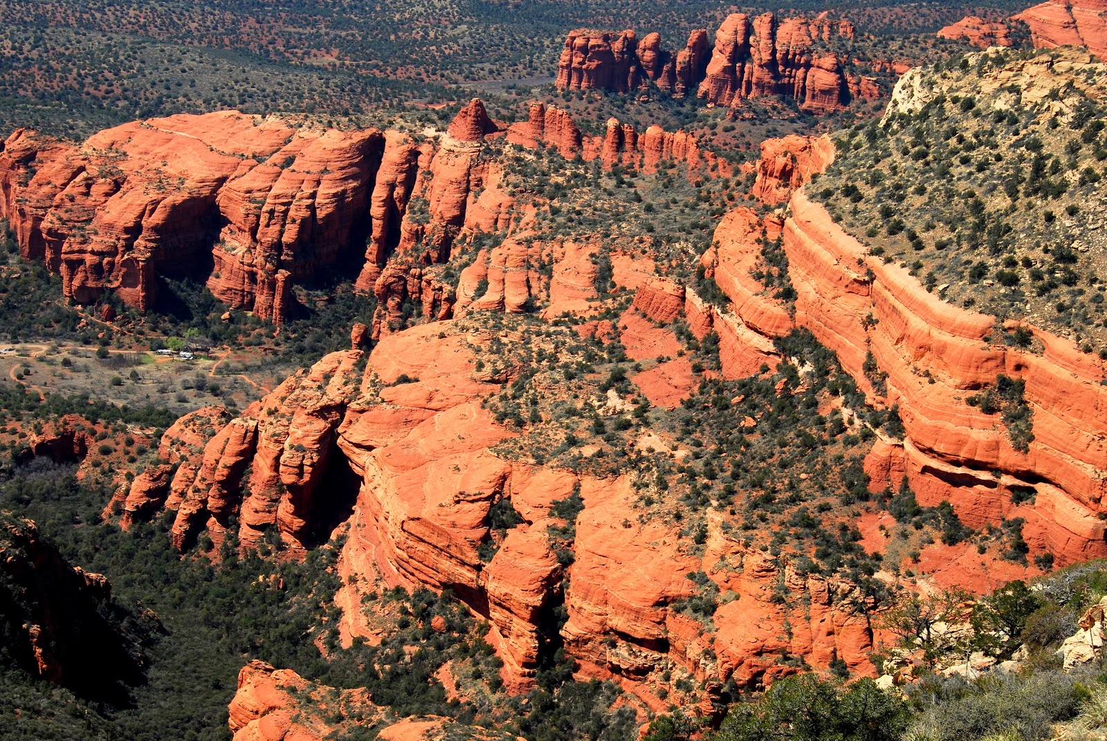 Today we travel to the mythical town of Sedona, a place we have not seen as the furthest south we have been (in this area) has been Flagstaff. We went to the tourist info centre for bike and hike trail info and asked a hiking person what would be the knarliest hike in town. He said when they were getting ready for the Grand Canyon they hiked up to Bear Mountain .So here we are on our way. Air is not warm but very pleasant for a brisk walk.  At 6500', the air is a bit cool after so much warm air in Tucson and Apache Junction. Meet lots of people going up and down. Many people fly in from all over the place and there are quite a few kids as this is the spring break for many.  In the distance is San Francisco Peak above Flagstaff with lots of snow on it.  We have travelled from Cottonwood to Sedona today for some mountain biking. Trails are pretty busy. The town is buzzing as there are a lot of kids on spring break along with a bunch of northern types trying to shake winter. 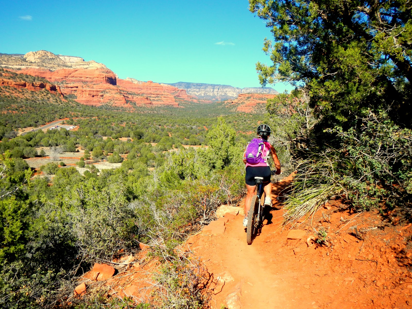 Mrs. Crosscheck on a 4 hour round trip of 4 trails in the Sedona area. Cockscolm-Dawa-Aerie-Long Canyon and a few others. Great red dirt single track, mostly intermediate, some very short sections of expert.  Do some touristy things in Sedona like buying some gifts and lickin ice cream and them tootle on up Oak Creek Canyon where we stop at a lunch area for a hiking trip up Wilson Mtn. This is a view on the way up of the red rock canyon.  Mrs Crosscheck on Wilson Mt. gazing down at Sedona and the red rock canyons. She knows that tomorrow we will be in the Grand Canyon and the temps are going to be freezing, at least on the rim.  Crosscheck, are you out of your mind. Get off that white stuff before you catch pneumonia. It's bad for your health. Crosscheck, are you out of your mind. Get off that white stuff before you catch pneumonia. It's bad for your health.Well, tonight we stay just up the road in a forestry CG and then drive past Flagstaff and on to the Grand Canyon for one hike, Grandview to South Kaibab. We say good by to the California and Arizona low deserts and welcome Utah. Some observations on our trip: 1) Just about all of the back road traffic signs in Arizona had mutiple bullet holes in them 2) The older working Americans that we talked to said they were working way too hard and too long. Most said that they couldn't afford to quit. 3) There are a lot of northern types that retire in the Tucson, Phoenix area judging by the eastern accents . We talked to a lot of Canucks who spend a lot of time in this area too. 4) You know how you can pick out a Canadian? They are the one's who are bragging to another Canuck about the bargain they just got on booze at Costco. 5) Solar works. 6) Not a lot of water in these holiday areas . 7) Last and most important, we met lots of good people and had a great time. Thanks to all the advance advise from members of RV.Net about the areas we travelled in. Dave  Posted with Blogsy Posted with Blogsy |
great stuff. fantastic pictures.
ReplyDeleteWonderful adventures -- thanks for posting this -- I am looking forward to Part II!
ReplyDelete